

|
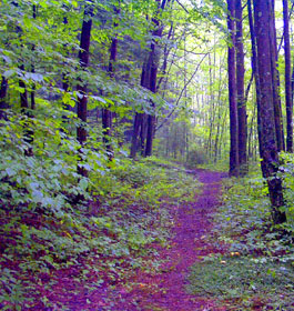
Enjoy 17 scenic miles of recreational trails for mountain bicyclists and hikers. This area is in Fannin County off of Aska Road, and less than 10 miles from downtown Blue Ridge, GA. |
| Aska Trail System General Information |
 Trail Description: Trails range in length from 1.0 mile to 5.1 miles and range in difficulty from easy to strenuous. The system utilizes hand dug tread way and old logging roads. These trails include Long Branch 2.5-mile loop, Flat Creek 5-mile loop, Green Mountain Trail, and Stanley Gap Trail. The area is accessed from Aska Road parking area at Deep Gap and from Stanley Gap and Shady Falls Road. A mixture of single track and former logging roads with elevations changes of 1,700 feet area encountered. These trails offer gentle to moderate hiking grades but are challenging. Trail is free and open all year. Trail Description: Trails range in length from 1.0 mile to 5.1 miles and range in difficulty from easy to strenuous. The system utilizes hand dug tread way and old logging roads. These trails include Long Branch 2.5-mile loop, Flat Creek 5-mile loop, Green Mountain Trail, and Stanley Gap Trail. The area is accessed from Aska Road parking area at Deep Gap and from Stanley Gap and Shady Falls Road. A mixture of single track and former logging roads with elevations changes of 1,700 feet area encountered. These trails offer gentle to moderate hiking grades but are challenging. Trail is free and open all year.
The Aska Trail System is blazed with lime green rectangles, indicating hiking is permitted, and yellow diamonds, indicating mountain bicycles are permitted. The Benton MacKaye Trail, which coincides with part of the System along the Stanley Gap Trail, is blazed with white diamonds. There is no water or restroom. Hikers are also allowed on these trails. Please use caution. |
|
NOTE: Hunting is allowed on National Forest Lands. This includes the Aska Trail System.
Open Dates: All year
Restrictions: No motorized vehicles or pack stock, including horses, is allowed on this trail system.
Mountain Biking and Day Hiking Trails Length : 17 miles total. See all trails info below.
Stanley Gap Trail - #165 - 4.8 miles in length - Difficulty is Moderate.
Flat Creek Loop - #165B - 5.1 miles in length - Difficulty is Moderate.
Flat Creek Connector - #165A - 0.2 miles in length - Difficulty is Moderate.
Long Branch Loop - #165G - 2.1 miles in length - Difficulty is Easy.
Long Branch Connector - #165F - 0.5 mile in length - Difficulty is Moderate.
Lower Green Mountain - #165D - 1.1 miles in length - Difficulty is Moderate.
Upper Green Mountain - #165C - 3.6 miles in length - Difficulty is Strenuous.
Water: None - Restroom: None |
| Contact, Directions & GPS Location |
USDA Forest Service, Blue Ridge Ranger District - Phone: 706-745-6928
Address: 2042 Highway 515 West, Blairsville, GA 30512 - The district office is on the north side of US Highway 76, 1.5 miles west of the intersection of US 76 and US 19 in the town of Blairesville, Georgia. Office hours: Monday - Friday at 8-12 & 1-4:30 pm
Chattahoochee-Oconee National Forests - Phone: 770 297-3000
Address: 1755 Cleveland Highway, Gainesville, GA 30501
Office hours: Tuesday - Friday at 9 - 12 & 1-4 - Closed Saturday, Sunday, and Monday |
Directions to 3 Aska Trail System trailheads.
Deep Gap Trailhead - From Blue Ridge, GA, go south on Aska Road 4.4 miles to Deep Gap parking area. The parking area is located south of the gap and on the right side of the road.
Stanley Gap Trailhead - From Blue Ridge, GA, go south on Aska Road 8 miles. Turn right on Stanley Creek Road (Toccoa Riverside Restaurant on left). Proceed straight for 4.1 miles. The parking area is located on the right side of the road.
Shady Falls Trailhead - From Blue Ridge, GA, follow Aska Road south 5.9 miles to Shady Falls Road. Turn left and proceed for 0.2 miles. The parking area is located on the left side of the road.
Aska Trail System GPS Location - Latitude is 34.816767 and Longitude is -84.299576. |
|
| |
|
Georgia US Forest:
 Camping Camping  Hiking Hiking
 Horseback Riding Trails Horseback Riding Trails
 Fishing Fishing Canoe Trails Canoe Trails
 GA US Forest Wilderness GA US Forest Wilderness
 Wilderness Preparation Wilderness Preparation
 Canoe Safety Tips Canoe Safety Tips
 Forest Safety Tips Forest Safety Tips
 GA U S Forest History GA U S Forest History

|


