

|
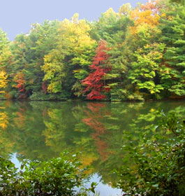
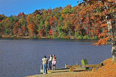
Dockery Lake Recreation Area offers camping, picnicking and fishing for all ages. The Dockery Lake Campground is small and located right along the banks of Dockery Lake.
 Campground Amenities: There are 11 camping sites (10 campsites and 1 campground host site with 1 flush facility in campground and 1 vault flush facility in day use area. Standard amenities including a grill, picnic tables, lantern post, etc are included. Water is turned off during cold months. Campground Amenities: There are 11 camping sites (10 campsites and 1 campground host site with 1 flush facility in campground and 1 vault flush facility in day use area. Standard amenities including a grill, picnic tables, lantern post, etc are included. Water is turned off during cold months.
Overlooking Dockery Lake and nestled deep off the side of a mountain, this recreation area offers camping, hiking, picnicking and fishing. The area offers 11 campsites with tables and tent pads. Hikers can enjoy the 3.4-mile Dockery Lake Trail, which provides access to the Appalachian Trail.
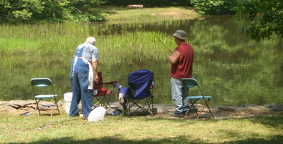
Fishing in Dockery Lake is popular also. Check State fishing regulations before fishing. The picnic area offers six picnic tables. Lake Winfield Scott Recreation Area offers similar recreation opportunities and is located to the south of Dockery Lake. Dockery Gap Scenic Overlook offers another spectacular view of north Georgia, and Woody Gap offers a breathtaking view as well. The Appalachian Trail also can be accessed at Woody Gap. Loop through recreation area is gravel.
Reservations Reservations are not required. Campsites are on a first come, first serve basis.
Fees: Camping-Full Service during 3/30 through 10/31 is $8 per night per site. Camping with Limited Services (no water; restrooms open at day use area only) during November 1 - December 31 is $4 per night. Day use is FREE.
Permit Info: Georgia fishing license and trout stamp required for fishing. |
|
Open: Mid- March through mid-December, though this varies slightly each year. Some years it's open mid-march through mid-December. Call the ranger office number at the bottom of this page before camping here. Open 24 hours a day. Quiet hours 10pm - 6am.
Restrictions: 14 day stay limit. Maximum 2 vehicles per campsite. Dogs must be leashed at all times.
 Closest Towns: The nearest town is approximately 12 miles, or 30 minutes, in Dahlonega, GA. Here campers will find restaurants, grocery stores, etc. Closest Towns: The nearest town is approximately 12 miles, or 30 minutes, in Dahlonega, GA. Here campers will find restaurants, grocery stores, etc.
Water: Drinking water is provided by faucets centrally located in the campground from the end of March through the end of October. Turned off during winter months.
Restroom Facilities: 1 Flush Facility and 1 vault facility at the day use area from 3/30 through 10/31. Turned off during winter months.
Passes: The Interagency Senior and Access Passes and the Golden Age and Access Passports are accepted. These passes entitle the pass holder to a 50% discount on camping fees.
Chattahoochee Outdoor Adventures Annual Pass: $50 Available by calling Chattahoochee Outdoor Adventures at 1-800-251-4800. This Annual Pass is valid at the following recreation areas for day use activities only: Lake Winfield Scott, Morganton Point, DeSoto Falls, Lakewood Landing Boat Launch, Toccoa River Sandy Bottoms, and Deep Hole.
Operated By: Chattahoochee Outdoor Adventures, INC. under permit by the US Forest Service. |
|
| More Recreation Activities |
Lake and Pond Fishing - In Dockery Lake designated trout waters - check State fishing regulations before fishing www.gofishgeorgia.com.
 Day Hiking Trails - Lakeshore Trail - 0.5 mile easy loop around lake. Dockery Lake Trail - 3.5 miles leads to the Appalachian Trail in Miller Gap. Day Hiking Trails - Lakeshore Trail - 0.5 mile easy loop around lake. Dockery Lake Trail - 3.5 miles leads to the Appalachian Trail in Miller Gap.
More Hiking Trails within a 30 minute drive - The Appalachian Trail cross Hwy 60 at Woody Gap, approximately 2 miles north. The Benton MacKaye Trail crosses Hwy. 60 in two places, approximately 12 miles north.
Picnicking - For those looking to spend the day at Dockery Lake, six lakefront picnic sites are available. These picnic sites can be accessed from the day use parking lot.
Boating - Non-Motorized - Dockery Lake - Carry down electric motors only |
| Contact, Directions & GPS Location |
USDA Forest Service, Blue Ridge Ranger District - Phone: 706-745-6928
Address: 2042 Highway 515 West, Blairsville, GA 30512 - Office hours: Monday - Friday at 8-12 & 1-4:30 pm
Chattahoochee-Oconee National Forests - Phone: 770 297-3000
Address: 1755 Cleveland Highway, Gainesville, GA 30501
Office hours: Tuesday - Friday at 9 - 12 & 1-4 - Closed Saturday, Sunday, and Monday
Directions From Blairsville, GA take U.S. 19/129 south for 10.0 miles, turn right on GA Hwy 180. Go approximately 11.0 miles. Turn left on GA Highway 60, go 4.0 miles to Forest Service Road 654 on the left. Turn left, go 1.0 mile to campground.
From Dahlonega, GA take GA Highway 60 north approximately 13 miles to Forest Service Road 654 on the right. Turn right, go 1.0 mile to campground.
GPS Location: Latitude is 34.66413 and Longitude is -83.98129. |
|
| |
|

Georgia US Forest Areas
 Camping Camping  Hiking Hiking
 Horseback Riding Trails Horseback Riding Trails
 Fishing Fishing Canoe Trails Canoe Trails
 GA US Forest Wilderness GA US Forest Wilderness
 Wilderness Preparation Wilderness Preparation
 Canoe Safety Tips Canoe Safety Tips
 Forest Safety Tips Forest Safety Tips
 GA U S Forest History GA U S Forest History

|


