

|
| Lake Rabun Recreation Area Camping & General Information |
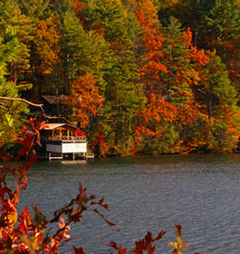
Cradled in North Georgia Mountains overlooking beautiful Lake Rabun, this recreation area offers camping, hiking, swimming, boating and fishing. Enjoy the peaceful lake scenery.
There are tent and trailer campsites in this family-oriented setting that will easily transform whatever gear you have into an outdoor home away from home.
 Campground Amenities - 81 Campsites - 21 with electricty and a majority with water. On-site camp host. 2 Restroom facilities with hot water showers. 2 Private restrooms ADA accessible. 2 Bath houses. Standard amenities including grill, picnic tables, lantern post,etc. Dump Station. Access to Lake Rabun Beach. Access to Lake Rabun Boat Ramp. Campground Amenities - 81 Campsites - 21 with electricty and a majority with water. On-site camp host. 2 Restroom facilities with hot water showers. 2 Private restrooms ADA accessible. 2 Bath houses. Standard amenities including grill, picnic tables, lantern post,etc. Dump Station. Access to Lake Rabun Beach. Access to Lake Rabun Boat Ramp.
Reservations Reservations are not required. Campsites are on a first come, first serve basis.
Fees: Camping: Loop1 Sites 1 - 53; Water & Non-electric $16 per site per night. Loop 2 Sites 54-85; Water & Electric $16 per site per night plus $9 per night per utilities. Swim Site is $6 per non-commercail vehicle per day. Over 4 people, $1 each additional person. Boat Launch is $4 per vehicle per day.
Permit Info: Georgia fishing license and valid boating registration.
Open: May1, 2016 through November 2, 2016. Call for specific dates. Quiet hours 10 pm to 6 am.
Closest Towns: The nearest town is approximately 15 miles, or 25 minutes, in Clayton, GA. Here campers will find restaurants, grocery stores, etc.
Water: Drinking water is provided by faucets at most sites.
Restroom Facilities: 2 Flush facilities
Passes: The Interagency Senior and Access Passes and the Golden Age and Access Passports are accepted. These passes entitle the pass holder to a 50% discount on camping fees.
Operated By: Chattahoochee Management, INC. under permit by the US Forest Service |
|
| More Recreation Activities |
RV Camping - Lake Rabun Beach Campground offers 21 campsites with electric hookup and water for full service RV camping
 Lake and Pond Fishing - Lake Rabun is a stocked lake. Fish Speciesa are Bass, Bream, Perch, Trout and Catfish. Fishing Platform is a pier. Lake and Pond Fishing - Lake Rabun is a stocked lake. Fish Speciesa are Bass, Bream, Perch, Trout and Catfish. Fishing Platform is a pier.
Day Hiking - Located at the rear of campground, visitors will find the trailhead for the popular Angel Falls/Panther Falls Hiking Trail (trail length 1.7 miles). Another trail area within a 30 minute drive at Tallulah Gorge State Park.
Picnicking - The swim area has eight picnic tables.
Boating - Motorized - Boat ramp, courtesy dock, fishing deck, and large paved parking lot that can accommodate vehicles with boat trailers are located adjacent to the campground.
Swimming - No lifeguard on duty at lake. Swimming area has accessible route from paved designated parking lot to picnic area; sand beach and swim area designated by buoys, bathhouse.
Waterskiing - Lake Rabun is a 835 acre mountain lake excellent for boating and waterskiing. |
|
| Contact, Directions & GPS Location |
USDA Forest Service, Chattooga River Ranger District office - Phone: 706-754-6221 - Address: 9975 Highway 441 S, Lakemont, GA 30552 -Monday - Friday at 8 am - 12 Noon and 1-4:30 pm. Closed 12 Noon - 1 pm.
The Chattooga River Ranger District covers 261,035 acres in the northeast part of Georgia. Terrain ranges from the Piedmont in the southern part of the district to Georgia's second highest mountain, Rabun Bald at 4,696 feet above sea level. To the east is the Chattooga Wild and Scenic River. In the central part of the district are Lake Burton, Seed Lake, and Lake Rabun where you'll find the Rabun Beach Campground. In the western part of the district are the headwaters of the Chattahoochee River and the Upper Chattahoochee River Campground. The Appalachian National Scenic Trail passes through the district. There are many waterfalls across the district including the twin waterfalls of Anna Ruby Falls Scenic Area.
Chattahoochee-Oconee National Forests - Phone: 770 297-3000
Address: 1755 Cleveland Highway, Gainesville, GA 30501
Office hours: Tuesday - Friday at 9 - 12 & 1-4 - Closed Saturday, Sunday, and Monday
Directions: Take U.S. 441/23 south from Clayton for 5.4 miles; turn right on Wiley Connector for 0.1 mile; turn left (south) on Georgia 15(Historic 441) for 1.4 miles; turn right on Lake Rabun Road (County Road 10) for 5 miles. If pulling a trailer, the best route is to go west on Hwy 76 for 7 miles; turn left on Charlie Mtn. Road for 3.5 miles; turn right on Bridge Creek Road for 2 miles; turn left on Burton Dam Road for 5.4 miles. The campground will be on your left.
Lake Rabun Recreation Area GPS Location - Latitude is 34.755767 and Longitude is -83.481299. |
|
| |
|

Georgia US Forest Areas
 Camping Camping  Hiking Hiking
 Horseback Riding Trails Horseback Riding Trails
 Fishing Fishing Canoe Trails Canoe Trails
 GA US Forest Wilderness GA US Forest Wilderness
 Wilderness Preparation Wilderness Preparation
 Canoe Safety Tips Canoe Safety Tips
 Forest Safety Tips Forest Safety Tips
 GA U S Forest History GA U S Forest History

|


