

|
| Morganton Point Camping & General Information |
This is the only developed campground located on the Blue Ridge Lake shoreline. This is a 3,290 acre TVA reservoir, near Blue Ridge, GA. Enjoy fun recreation including camping, picnicking, hiking, boating, skiing and fishing.
 Overlooking beautiful Lake Blue Ridge in the north Georgia mountains, this recreation area has it all! This area offers campsites, picnic tables and a shelter to enjoy. A paved boat launch has two ramps and is located near the campground. Hikers can enjoy a scenic trail that parallels the lake shore. Fishing and swimming in the clear 3,290-acre lake is popular also. Loop through the recreation area is paved. Area has a few campsites that are accessible to people with disabilities, and has one accessible restroom. Overlooking beautiful Lake Blue Ridge in the north Georgia mountains, this recreation area has it all! This area offers campsites, picnic tables and a shelter to enjoy. A paved boat launch has two ramps and is located near the campground. Hikers can enjoy a scenic trail that parallels the lake shore. Fishing and swimming in the clear 3,290-acre lake is popular also. Loop through the recreation area is paved. Area has a few campsites that are accessible to people with disabilities, and has one accessible restroom.
Campground Camping: The 20 reservation sites have water hook-ups at each site, except 11 & 14. Electrical hookups are not available at tent sites. Some sites have electrial hookups and only. Some sites have electric hookups and water. While other campsites have electrical hookups, water and sewer amenities. All sites are a short walk to the lake.
There are 44 sites with 2 group sites and 7 tent walk-in sites. There is Paved boat ramp with parking. The designated beach area has a bath house. The picnic area includes a 1 covered picnic pavilion. Campsites have a grill, picnic tables, lantern post, etc.
Reservations - Required-Sites are #1 through #20. Call 1-877-444-6777 or go to www.recreation.gov to reserve.
Fees: Camping - Call for camping fees. Fees vary on what amenties are included. Please note that waterfront campsites cost slightly more than non-waterfrong areas. Day Use is $5 per vehicle per day.
Permit Info - Georgia fishing license and valid boating registration. |
|
Restrictions - No alcoholic beverages in Campground and Day Use Areas. 14 day stay limit.
2 vehicles per campsite, except for group sites (#9, #13) four vehicles are allowed. Boat trailers and self propelled campers count as a vehicle. All guest or visitors must park in day use area and pay parking fee. Dogs must be leashed at all times.
 Open: Mid-April through end of October 24 hours a day. Closed rest of year. Quiet hours are 10pm – 7am. Open: Mid-April through end of October 24 hours a day. Closed rest of year. Quiet hours are 10pm – 7am.
Closest Town - The nearest town is approximately 8 miles, or 15 minutes, in Blue Ridge, GA. Here campers will find restaurants, grocery stores, etc.
Water: Drinking water is provided by faucets centrally located in the campground
Restroom Facilities: 3 flush facilities, 2 with showers
Passes: Interagency Senior and Access Passes, Golden Age and Access Passports are accepted. These passes entitle the pass holder to a 50% discount on camping and some day use fees.
Chattahoochee Outdoor Adventures Annual Pass: $50. Available by calling Chattahoochee Outdoor Adventures at 1-800-251-4800. This Annual Pass is valid at the following recreation areas for day use activities only: Lake Winfield Scott, Morganton Point, DeSoto Falls, Lakewood Landing Boat Launch, Toccoa River Sandy Bottoms, and Deep Hole.
Operated By: Chattahoochee Outdoor Adventures, INC. under permit by the US Forest Service. |
|
| More Recreation Activities |
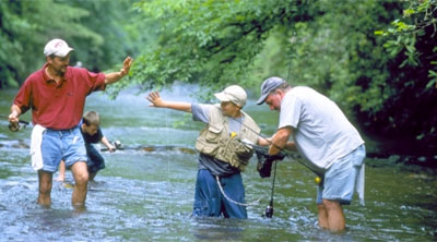
Lake and Pond Fishing - Fishing for bass, crappie, etc. in the 3,290-acre lake is popular.
Picnicking - Picnickers have 13 picnic tables and a covered shelter to enjoy.
Boating - A paved boat launch has two ramps and is located near the campground. Electric motors only are allowed.
Trails within a 30 minute drivey - The Aska Trail System provides approximately 17.0 miles of recreational trails for bicyclists and hikers. |
| Contact, Directions & GPS Location |
USDA Forest Service, Blue Ridge Ranger District - Phone: 706-745-6928
Address: 2042 Highway 515 West, Blairsville, GA 30512 - Office hours: Monday - Friday at 8-12 & 1-4:30 pm
Chattahoochee-Oconee National Forests - Phone: 770 297-3000
Address: 1755 Cleveland Highway, Gainesville, GA 30501
Office hours: Tuesday - Friday at 9 - 12 & 1-4 - Closed Saturday, Sunday, and Monday
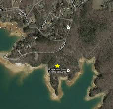
Directions: From Blue Ridge, GA take US 515 north for 4 miles to GA Hwy. 60; turn right and go 0.5 miles to stop sign. Turn left, go 1.5 miles to the town of Morganton, GA. In Morganton, turn right on County Road 616 for 1 mile.
Morganton Point Campground GPS Location - Latitude is 34.869225 and Longitude is -84.24942 |
|
| |
|

Georgia US Forest Areas
 Camping Camping  Hiking Hiking
 Horseback Riding Trails Horseback Riding Trails
 Fishing Fishing Canoe Trails Canoe Trails
 GA US Forest Wilderness GA US Forest Wilderness
 Wilderness Preparation Wilderness Preparation
 Canoe Safety Tips Canoe Safety Tips
 Forest Safety Tips Forest Safety Tips
 GA U S Forest History GA U S Forest History

|


