 |
||
To view the specific Covered Bridge's name, pictures, map and detailed information, put your mouse cursor over the black circle and click on it. Stay and Play in GA! |
||
Georgia's Covered Bridges Interactive Map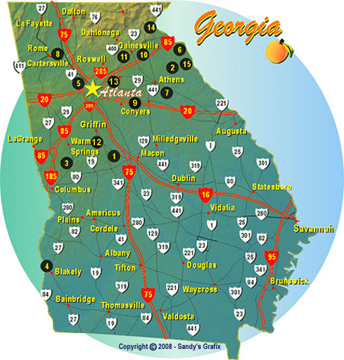
|
||
Click on a link on the map above, or the text link below for covered bridge information, pictures, map and directions. |
||
| Georgia has held onto more historic covered bridges than most people realize, and we have tracked down every one still standing for this guide. Most date back to the 1800s, built with wooden truss designs that kept the load-bearing timbers dry for over a century. A handful, like the one in Stone Mountain Park, are relocated pieces of Georgia history rather than original crossings, and we note that on each bridge's own page. They make a nice detour on a fall driving tour, and several sit close enough together that you can string a handful into one afternoon trip. | ||
Bridges Are: Auchumpkee Creek Bridge in Thomaston  Big Cloud Creek Bridge in LexingtonCallaway Gardens Bridge in Pine Mountain Coheelee Creek Bridge in BlakelyConcord Bridge in Smyrna Cromer's Mill Bridge in Carnesville Elder's Mill Bridge in WatkinsvilleEuharlee Bridge in CartersvilleHaralson Mill Bridge in ConyersLula Bridge in GainesvillePoole's Mill Bridge in CummingBig Red Oak Creek Bridge in WoodburyStone Mountain Park Bridge in Stone MountainStovall Mill Bridge in HelenWatson Mill Bridge in Comer Big Cloud Creek Bridge in LexingtonCallaway Gardens Bridge in Pine Mountain Coheelee Creek Bridge in BlakelyConcord Bridge in Smyrna Cromer's Mill Bridge in Carnesville Elder's Mill Bridge in WatkinsvilleEuharlee Bridge in CartersvilleHaralson Mill Bridge in ConyersLula Bridge in GainesvillePoole's Mill Bridge in CummingBig Red Oak Creek Bridge in WoodburyStone Mountain Park Bridge in Stone MountainStovall Mill Bridge in HelenWatson Mill Bridge in Comer |
||
|