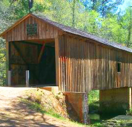
Welcome to www.n-georgia.com Discover Georgia's Coheelee Creek Bridge - The Covered Bridge Trail of Georgia, Inc. was founded in 1998 to preserve and promote the last 15 of the many covered bridges that once existed in Georgia. Checkout the online and printable Georgia covered bridges maps. This covered bridge's description, picture, contact phone number and directions are provided below. Enjoy!
Free Stuff To Do In Georgia Georgia Overnight Accommodations Shopping in Georgia Videos of places and things to do in Georgia Georgia Real Estate Services Weather in Georgia Maps of places in Georgia Contact Us Advertise in N-Georgia.com

N-Georgia.com Website

Georgia's 9 Travel Regions

Georgia Monthly Festivals and Events
Georgia Festivals and Events
Georgia State Parks
Georgia County Parks
Georgia Wildlife Resources Division Areas
Georgia Horseback Riding Trails
Georgia Mountain Bike Trails
Georgia Off Highway Vehicle Trails
Georgia Covered Bridges
Georgia Driving Tours
Georgia Waterfalls
Georgia Lakes
Georgia Coast and Islands
Georgia Planetariums and Observatories
Georgia Audubon Society
Georgia Gardens
Georgia Farmers Markets
Georgia Historic Sites
Georgia Civil War Sites
Georgia Museums
Miscellaneous Fun Activities
Georgia Tourist Centers
Coheelee Creek Covered Bridge
Coheelee Creek Bridge - Phone: 229-723-3741 - In Blakely, GA (Early Co.)
Bridge Description: This bridge was built in 1891 by J. W. Baughman and is 96 feet long. The truss style is Modified Queen Post. It is at the Coheelee Creek. Thee is a historic marker, picnic area and parking area. It has also been know as Bridge at McDonald's Ford.

This bridge is the southernmost (historic/authentic) covered bridge in the United States. The late Dr. John H. Goff, University of Georgia, studied unique Georgia placenames for many years and wrote a series of articles on them. He explains the variation in many Indian names come from the switching back and forth from the Indian dialects to English and then back to the dialects again. And so the name COHEELEE is a good example of this practice. In the 1820's this narrow rambling creek, that rises about "a half mile" west of Blakely, was labeled "BIG CREEK" on surveyor Robert Kennedy's map but according to Mary Grist Whitehead, "somehow the Indian name survived and was preferred by the early settlers." -From "Covered Bridges of Georgia" by Thomas L. French, Jr. & Edward L. French.

Built in 1891, this bridge uses steel rods as tension members in it's truss design. The result is similar to a queen post or Warren truss. The angled rods make the bridge unique, certainly in Georgia if not the entire US. The use of steel rods was fairly common for the late 19th century and can also be seen on the Concord Road Bridge and the Lula Bridge.

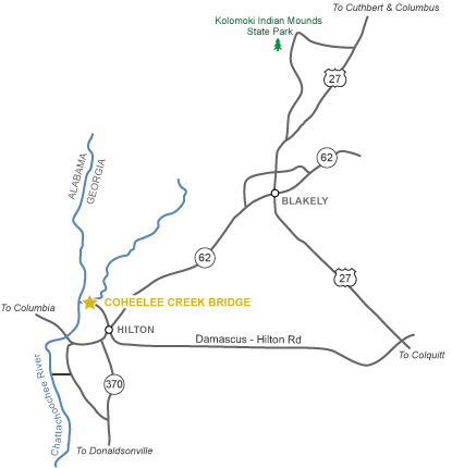
Directions: From Columbus, go 89 miles south to Blakely and then 9 miles southwest off Hwy. 62. In the Plantation Trace tourist region.
Coheelee Creek Covered Bridge Map

Online Georgia Covered Bridges Map
Georgia covered bridges online map.

Printable Georgia Covered Bridges Map
Georgia covered bridges printable map.

Bullet

Return to Georgia
Covered Bridges Page


HomeFree Stuff To Do - Festivals & Events - Monthly Events - State Parks - County Parks  - Georgia National ForestsWildlife Areas    
Horseback Riding Trails - OHV Trails - Bike Trails - Driving Tours - Covered Bridges - Civil War Sites - Historic Sites - Museums & Art Galleries
Coast & Islands - Lakes - Waterfalls - Gardens - Planetariums - Audubon Society  - Farmers Markets - Miscellaneous Fun
9 Travel Regions -  Tourist CentersVisitor Information Centers  - MapsVideos - Safety Tips - Lodging - Shopping - Real Estate
Advertising Opportunities  -  Contact

Website created and Copyright ©2008 by Sandy's Grafix. All rights are reserved. Website updated on 7/11/08