Visit Fannin County and City Parks - Featuring Lake Blue Ridge, Aska Trails Area, Cohutta Wilderness Area, Cooper Creek Scenic & Recreation Area in the Chattahoochee National Forest and more. For more info, please call the phone numbers listed with the parks below.
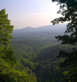
Aska Trails Area is a hiking and mountain biking trail system 17 miles in length developed in the Chattahoochee National Forest. Open daily, all year. Phone: 706-632-5680 - Location: Aska Road, Blue Ridge Georgia 30513 - Directions: I-575 to Blue Ridge. Ask at Visitor Center.
Blue Ridge City Park encompasses 2 blocks and is a popular place for picnics, community gatherings and festivals. It is also home to a family of roosters, hens and chicks! Carriage rides are available at the park on weekends. Located in the heart of downtown Blue Ridge Georgia Phone: 706-632-5680 or toll free at 1-800-899-MTNS (6867)
Cohutta Wilderness Area is comprised of 34,102 acres in the Cohutta Mountains, part of the Blue Ridge Mountain chain. The area is suited for the experienced outdoorsman, with primitive hiking trails, camping and trout fishing in the Conasauga and Jacks Rivers. Phone: 706-632-3031 Location: 6050 Appalachian Hwy., Blue Ridge Georgia 30513. Directions: From intersection of GA 52/US 411 in Chatsworth, follow US 411 north for 7.3 miles to Grassy St. Turn right onto Grassy St just after the Crandall Post Office. Follow Grassy St until you cross a set of railroad tracks, then turn right onto Crandall-Ellijay Road. Follow it for only 0.1 miles, then turn left onto Forest Service Road 630 (which is also known as Mill Creek Road). Follow FS 630 (which turns to gravel in about 0.5 miles) for about 9 miles to a four way intersection with Forest Service Road 17. Do not turn onto FS 17, continue straight across FS 17 on FS 630 to find the parking area.
Cooper Creek Scenic & Recreation Area in the Chattahoochee National Forest -
4 of the 17 camp sites are on the banks of Cooper Creek. Amenities include picnic tables, tent pads and grills. This recreation area offers camping, hiking and trout fishing. Hikers can enjoy the Yellow Mountain Trail, which follows an old logging road for 3.6 miles through forests of hemlock, pine and hardwood. Other hiking trails that start at this recreation area include the 2.4-mile Mill Shoals Trail, and the Cooper Creek Trail, which is a 0.4-mile connecting trail. Fishing in Cooper Creek and in Mulky Creek for stocked and wild trout is popular. Cooper Creek Scenic Area joins the recreation area and features 1,240 acres with hiking trails and fishing more tributaries of Cooper Creek. Phone: 706-632-3031 - Location: F.S. Rd. #4, Blue Ridge Georgia 30513 - Directions: Off Hwy. 60
Deep Hole Campground - 706-745-6928 Campground Amenities: Located along the banks of the Toccoa River, this recreation area offers camping, boating and fishing. The campsites are equipped with tent pads and picnic tables. 8 campsites are available. The canoe launch makes river access very easy. Floating down the Toccoa River is very popular among visitors. Fishing for rock and smallmouth bass, rainbow and brown trout is popular among anglers. Canoe/Kayak launch on the Toccoa River. Paddle the Toccoa River Trail. Deep Hole Recreation Area has toilets and drinking water available. Each site is equipped with a picnic table, tent pad and grill. Restrooms and some campsites are accessible to people with disabilities; path to canoe launch and fishing deck is also accessible. Camping fee is required.
Open Dates Area is open all year and is open 24 hours a day for campers. Directions: From Blue Ridge, take Hwy. 76 east for 5 miles to Morganton; turn right on Hwy. 60 south for 16 miles. Contact 706-745-6928 or 706-632-3031 - USDA Forest Service, Blue Ridge Ranger District
Fannin County Recreation Department Multi-Purpose Center - 107 acres in size. Has an indoor elevated walking track, four regulation sized basketball courts, two meeting rooms, a conference room and a full kitchen as some available amenities. Approximately40 developed into soccer fields, baseball and softball fields, football fields, two concession stands and a large parking lot. Picnic pavilions adorn another fifteen acre tract along with bicycle trails and walking trails. The remaining acres will hold a youth center with basketball courts, and tennis courts. The complex is open year-round. Call for reservations of picnic shelters or other information. Phone: 706-632-7696 - Located on Tom Boyd Road, Blue Ridge Georgia 30513 - Directions From Atlanta: 575 N to 515N thru Cherokee, Pickens and Gilmer counties to Fannin. turn left at 3rd light (hwy 5 by McDonalds) Approx 1/2 mile to Tom Boyd road on right. follow signs to park
Frank Gross Campground - 706-745-6928 Campground Amenities: Located along the banks of Rock Creek and far from civilization, this area offers camping, hiking and trout fishing. There are nine campsites with picnic tables, tent pads and grills. Hikers can enjoy the Appalachian Trail nearby and it can be accessed easily from Forest Service Road 69. Another beautiful hike is along the Benton MacKaye Trail to the north of Frank Gross; this trail crosses the Toccoa River on a suspension bridge that is 260 feet long. Fishing in Rock Creek and Mill Creek for stocked and wild trout is popular. Good, hard-surface roads until you reach Forest Service Road 69; this is a gravel road and is crooked and steep in parts. Restrooms have railings but are small; path to restrooms is paved. Drinking water is available at this site. Camping fee is required.
Open Dates Area is open from late March until the end of October Directions: From Blue Ridge, take Hwy. 76 east for 5 miles to Morganton; turn right on Hwy. 60 south for 15 miles. Turn right on Forest Service Road 69 for 5 miles. Contact 706-745-6928 - USDA Forest Service, Blue Ridge Ranger District
Horseshoe Bend River Park -Horseshoe Bend River Park is a passive park. The park is open year-round. It is designed for group gatherings, such as family reunions, church groups, birthday parties, company groups and more. A perfect setting for a family picnic or a place to just get away and enjoy the tranquility. Fish, hike, picnic or just relax on a bench along the river banks of the Toccoa River. Playground areas, 2 picnic shelters, picnic tables, horseshoe pits, volleyball courts, grills and restrooms are available. Phone: 706-632-7696 - Location: River Rd, McCaysville, Georgia 30555 Directions: GA Hwy. 5 & 515 to US Hwy. 76.
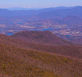
Lake Blue Ridge Recreation Area is surrounded by the majestic north Georgia mountains, Lake Blue Ridge offers camping, picnicking, hiking, boating, skiing and fishing. The crystal clear aquamarine waters of Lake Blue Ridge make it one of Georgia's most picturesque mountain lakes. The 3,290-acre lake and surrounding area offers over 90 national forest campsites, several boat ramps, a full-service marina and public swimming and picnic areas. 80 percent of the shoreline on Lake Blue Ridge is in the Chattahoochee National Forest, managed by the USDA Forest Service. The waters of Lake Blue Ridge with the Blue Ridge Mountains behind The lake is home to bass, bream, catfish, perch, walleye and crappie.
Blue Ridge reservoir is 11 miles long and has 65 miles of shoreline, 25 percent of which is developed. The lake was formed when Blue Ridge Dam was constructed on the Toccoa River in 1930 by the Toccoa Electric Power Company. At the time it was built, the dam was the largest earthen dam in the Southeast. The Tennessee Valley Authority (TVA) purchased the facility in 1939 for hydroelectric power production. Click on link above for more info. Phone: 706-632-3031 Location: Dry Branch Road, Blue Ridge Georgia 30513 and Off Hwy. 60 in Morgantown, Georgia
Mulky Campground - 706-745-6928 Campground Amenities: Located along beautiful Cooper Creek, this recreation area offers camping, hiking and fishing. The camping area is across the road from the creek, and offers 11 sites with picnic tables and grills. Hikers enjoy the Yellow Mountain Trail, which follows an old logging road for 3.6 miles through forests of hemlock, pine and hardwood. Other hiking trails nearby include the 2.4-mile Mill Shoals Trail, and the Cooper Creek Trail, which is a 0.4-mile connecting trail. Fishing in Cooper Creek and in Mulky Creek for stocked and wild trout is popular. Cooper Creek Scenic Area joins Cooper Creek Recreation Area and features 1,240 acres with hiking trails and fishing more tributaries of Cooper Creek. Good, hard-surface roads until you reach Forest Service Road 4; this is a gravel road and is crooked and steep in parts. Facility is accessible for the disabled; campsites are all on flat ground and restrooms are accessible. Drinking water is available. Camping fee required.
Open Dates Area is open from late March until the end of October. Directions: From Blue Ridge, take Hwy. 76 east for 5 miles to Morganton; turn right on Hwy. 60 south for 16 miles. Turn left on Forest Service Road 4 for 5 miles.
Contact 706-745-6928 - USDA Forest Service, Blue Ridge Ranger District
Morganton Music Park features live country and bluegrass music and dancing Friday and Saturday nights 8 to 11 p.m. Square dancing, clogging, 2-step and line dancing, with lessons from 6 to 7 p.m. Snack Bar. Open Friday and Saturday nights 8 to 11 pm. year round. Phone: 706-374-5230 - Location: 70 Fain Street, Morganton, Georgia United States 30560 - Directions: I-575 to Blueridge, then take Hwy 60 to Morganton.
Morganton Point Recreation Area is overlooking beautiful Lake Blue Ridge in the north Georgia mountains, this recreation area offers camping, picnicking, boating, fishing and hiking. This area offers 37 campsites, and picnickers have 13 picnic tables and a shelter to enjoy. Phone: 706-632-3031 - Location: County Rd 616, Morganton, GA 30560 - Directions: Hwy 60
Tammen Park is an athletic and passive park. It has a large multi-purpose baseball-softball diamond, with access to the Toccoa River for fishing. Tammen Park also has a 75 foot long fishing pier, 2 picnic shelters, sidewalks, picnic tables, grills and playground area. This is a perfect place for groups and gatherings or just a place to get away and enjoy the serenity. Park is open year-round. Phone: 706-632-7696 - Located off Hwy 515 just below the Blue Ridge Dam
Toccoa River Canoe Trailoffers a canoe trail ideal for beginners and those who want to float and flyfish. The Toccoa River Canoe Trail utilizes 17 miles of the Toccoa River from Deep Hole Recreation Area to Lake Blue Ridge. Enjoy viewings of forested public lands, pastoral private lands, laurel and rhododendron thickets, coupled with great fishing and some rapids. Open daily, year round. Click on link above for more info. Phone: 706-632-3031 - Location: Highway 60 South, Blue Ridge Georgia 30513 - Directions: Hwy 76 to Morganton, then Hwy 60 S. 16 miles.