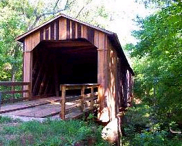
Visit Howard's Covered Bridge in Lexington Georgia - Formerly known as Big Clouds Creek Bridge - Located in Lexington, GA, Howard's Covered Bridge was built in 1840 by Mr. Hunt and Washington King going over the Red Oak Creek in Oglethorpe County.
Howard's Bridge - Formerly known as Big Clouds Creek Bridge Phone: 706-743-3113 or 706-743-5270 - In Lexington Georgia (Oglethorpe Co.) Bridge Description: This bridge goes over the Big Cloud's Creek. It was build in 1904-05 and is 164 feet long. Constructed in the Town lattice design using convict labor, the 164-foot bridges web of planks crisscrosses at 45-to 60-degree angles and are fastened with wooden pegs, or trunnels, at each intersection. The south Georgia timber used in the bridge was transported to Smithonia via the Smith and Dunlap Railroad, a standard gauge steam railroad connecting the farm complex of James Monroe Smith with the Georgia Railroad at Dunlap. Located in a very isolated section of historic Oglethorpe County, this bridge suffered from neglect and was in desperate need for rehabilitation. Some of the pictures below show the bridge while it was being repaired during April 1998. Those repairs are now complete.
The original builder of this bridge is listed in Covered Bridges of Georgia as a "Mr. Hunt," which probably is the same person who is known to have built Cromer's Mill bridge: J. M. "Pink" Hunt. The Covered Bridge Trail of Georgia brochure states that this bridge was built by Pink Hunt and Washington King together.
Whoever built the bridge was ambitious: this bridge had the longest main span, 130 feet, of any surviving bridges. At some point in time a wooden pier was built to shore up the long span so the claim of longest unsupported span now belongs to the Red Oak Creek bridge.
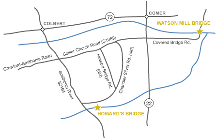
Directions: From Athens, take Hwy. 72 east to Colbert, south to Smithsonia and E on Chandler Silver Rd. In Watson Mill State Park in the Classic South Travel Region in Oglethorpe County.


 Howard's Bridge - Formerly known as Big Clouds Creek Bridge