Explore the historic Euharlee Creek Covered Bridge in Cartersville Georgia.
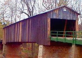
Formerly known as Lowry Bridge, this bridge was built in 1886 by Washington W. King over the Euharlee Creek in Bartow County. The bridge is listed on the National Register for Historic Places as part of the Etowah Valley Historic District.
Euharlee Creek Covered Bridge - Phone: 770-607-2017 - Address - 116 Covered Bridge Rd SW, Euharlee, GA 30120 (Bartow Co.)
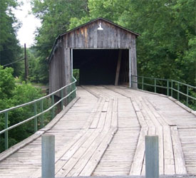
Description: This bridge was built in 1886 by Washington W. King. It is 137.6 feet long by 16.35 feet wide, and the truss is Town Lattice style. This bridge goes over Euharlee Creek. It has also been formerly known as Lowry Bridge. There is a parking area.
This covered bridge has been well maintained by the local folks. In The museum is located next to the bridge, in the “Miller’s House,” at 118 Covered Bridge Road, Euharlee, GA 30145.
The bridge is open 7 days a week. The museum is open Wednesday-Saturday 10am until 5pm, and Sunday at 1 until 5pm. Please call ahead to schedule group tours.
Free admission and parking.
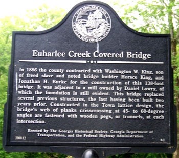
The bridge is located adjacent to the ruins of an old mill once owned and operated by Daniel Lowry who owned most of the land around the bridge and also allowed the builders to use rock from his land to build the piers of the bridge after high water swept a previous, lower bridge away.
According to Thomas and Edward French in Covered Bridges of Georgia "He also helped to rebuild the wooden structure. Due to the fact the bridge was swept from its foundation and perhaps came to rest against the mill's south wall, it may have been salvaged. This could account for the numbering of the web members of the town lattice trusses."
According to the North Georgia Journal a previous bridge collapsed causing the death of a local man, Mr. Nelson, a mule and a horse. His two young sons emerged from the disaster unscathed.
This led to the eventual construction of the present, much sturdier bridge by W.W. King (with perhaps some help from his father though Horace was ill atthe time). The maker's mark is shown at left. This numbering scheme made assembly of the final parts easier.
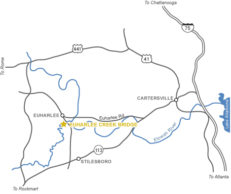
Directions from Atlanta: Go I-75N to Exit 288. Go south on GA 113 about 4.5 miles, then right on Euharlee Road. Go 5.5 miles on Euharlee Road, then turn left onto Covered Bridge Road.


 The bridge is located adjacent to the ruins of an old mill once owned and operated by Daniel Lowry who owned most of the land around the bridge and also allowed the builders to use rock from his land to build the piers of the bridge after high water swept a previous, lower bridge away.