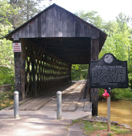
Visit Poole's Mill Covered Bridge and Park in Cumming Georgia
This 1901 covered bridge was built by Bud Gentry over Settledown Creek in Forsyth County.
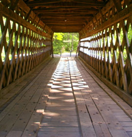
Bridge Description: This bridge was built in 1901 by Bud Gentry. It is 94.6 feet long by 14.5 feet wide. It's truss is town lattice. It runs over Settendown Creek. There are lots of fun park amenities here. See a bird's eye video at the bottom of this page.
North Georgia is blessed with a wild and beautiful land. The fingers of the foothills of the Appalachian Mountains spread over the north central part of the State and become the watershed to the Atlantic Ocean and the Gulf of Mexico with every valley nourished by lively streams.
The pioneers of the state came to lay the foundations for their homes, mills and churches here. Because of the rugged land and poor transportation, settlements sprang-up close together.
The site of the bridge dates back to the 1820's. The original construction of this bridge began with a contractor who drilled all the holes in the lattice members in the wrong place. After fitting up the pieces he realized they were in the wrong place and abandoned the project. Work was finished by Bud Gentry but required drilling new holes in the old members.
You can still see the misplaced holes today. Even the treads of the bridge are members that could not be used because of the misplaced holes. Treads with holes side-by-side were to have been used in the chords, while those with diagonally offset holes would have been lattice members.
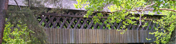
Though this bridge is quite sound structurally. With the addition of a new pier in the middle, new weatherboarding, and a new wood shingle roof, this bridge looks as good as new.
The pier in the middle of the creek was built during the 1998 rehab to take the sag out of the bridge and provide support. First a cofferdam was built and water was pumped out to give a dry work area. Then the bridge was jacked up in the middle lifting its end off of the abutment. Over a few days the bridge deformed under its own weight and settled back onto the abutment. Incremental jacking continued until the bridge was reasonably straight.
Though it never was made totally straight (you can see the sag a little in the picture at right) the weatherboarding was cut straight along the bottom to hide the sag. For the sake of authenticity the pier was given a smooth concrete finish rather than trying to make it look like part of the original bridge by finishing it with rock facing.
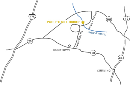
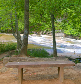
Poole's Mill Park is a super nice park. This scenic park includes nature trails, cascading falls, a garden, creekside picnic tables with grills, terrific playground, large Pavilion, trash cans, restrooms and a large parking lot.
It is a one-of-kind passive park, It is 10 acres of property that showcases the unique Pooles' Mill Covered Bridge. Built in 1901, this covered bridge spans the shoals of Settendown Creek. This bridge is closed to automobile traffic but open for walking. There is a memorial garden near the pavilion that was built in memory of Charles Welch. The park, on the National Historic Registry, offers residents the opportunity to picnic, walk and reminisce about the history of a bygone era. This is a nature park with a natural walking trail, benches and large pavilion with restrooms. This park closes in the winter and re-opens in the spring.
The trails are in a woodland area. They are wide, and are easy to walk and navigate through. There are lots of benches along the trails where you can rest and just sit and enjoy the scenery. You will enjoy watching the cascading falls.
The children's playground is fantastic! It has excellent and elaborate quality play equipment. It is a safe playing environment with setting areas. There are large grassy areas for playing games like baseball, softball, football, throwing frisbies and more. Very nice!
This park is amazing! It is clean and well maintained. It has well-shaded woodland areas throughout. It even has restricted smoking areas. It is handicap accessible. This is truly a "Georgia Hidden Treasure." Best of all it offers FREE admission and parking.


 Bridge Description:
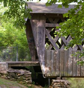 The site of the bridge dates back to the 1820's. The original construction of this bridge began with a contractor who drilled all the holes in the lattice members in the wrong place. After fitting up the pieces he realized they were in the wrong place and abandoned the project. Work was finished by Bud Gentry but required drilling new holes in the old members.
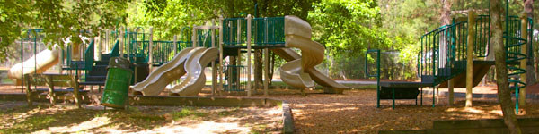
 It is a one-of-kind passive park, It is 10 acres of property that showcases the unique Pooles' Mill Covered Bridge. Built in 1901, this covered bridge spans the shoals of Settendown Creek. This bridge is closed to automobile traffic but open for walking. There is a memorial garden near the pavilion that was built in memory of Charles Welch. The park, on the National Historic Registry, offers residents the opportunity to picnic, walk and reminisce about the history of a bygone era. This is a nature park with a natural walking trail, benches and large pavilion with restrooms. This park closes in the winter and re-opens in the spring.